Jump to navigation
NR Colorado Department of Natural Resources
Pages
- Geologic map and coal measures of the Axial quadrangle, Moffat and Rio Blanco counties, Colorado
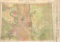
- Geologic map of Colorado
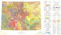
- Geologic map of Colorado
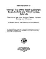
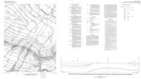
- Geologic map of the Basalt quadrangle, Eagle, Garfield and Pitkin Counties, Colorado
- Geologic map of the Basin Mountain quadrangle, La Plata County, Colorado
- Geologic map of the Cameron Mountain quadrangle, Chaffee, Park, and Fremont Counties, Colorado
- Geologic map of the Carbondale quadrangle, Garfield County, Colorado
- Geologic map of the Cottonwood Pass quadrangle, Eagle and Garfield Counties, Colorado
- Geologic map of the Dotsero quadrangle, Eagle and Garfield Counties, Colorado
- Geologic map of the Glenwood Springs quadrangle, Garfield County, Colorado
- Geologic map of the Glenwood Springs quadrangle, Garfield County, Colorado
- Geologic map of the Leon quadrangle, Eagle and Garfield Counties, Colorado
- Geologic map of the Manitou Springs quadrangle, El Paso and Teller counties, Colorado
- Geologic map of the Mount Sopris quadrangle, Garfield and Pitkin Counties, Colorado
- Geologic map of the Salida East quadrangle, Chaffee and Fremont Counties, Colorado
- Geologic map of the Shoshone Quadrangle, Garfield County, Colorado
- Geologic mapping and subsurface well log correlations of the late Cretaceous Fruitland Formation coal beds and carbonaceous shales : the stratigraphic mapping component of the 3M Project, San Juan Basin, La Plata County, Colorado
- Geologic model of the Purgatoire River Watershed within the Raton Basin, Colorado
- Geological Society of America meeting highlights CGS activities
- Geology and mineral evaluation of mineral claims with the Snowmass Wilderness Area : in the vicinity of the Colorado-Highland Marble Quarry, Conundrum Creek, Pitkin County, Colorado
Pages
